OnX and property lines

backyardtndeer

Well-Known Member
Joined
Jul 29, 2015
Messages
21,401
Location
West Tennessee
Did that climber belong to the adjacent landowner you think? I found a guy hunting a marked tree on my place once, dividing my property from another landowner.
Don't think it is his, he doesn't hunt. He could have let someone on him though. I don't really get along with him, have helped him time and again and he is just a yankee douche that tries to take advantage.

Either way where it's at, they were sitting next to the oaks that are on my property, and looking at the soybean plot that I had in. I suspect the owner of the climber came across the neighboring property to get to where the stand is hung. I put a camera on it the day I found it, never had anyone come to it, and it still sits there in the same position on the tree that is been for about a year now.
 

Lost Lake

Well-Known Member
Joined
Nov 17, 2012
Messages
5,117
Location
Middle Tn
Likely the property owners have gone back and painted their version of the line. I deal with this EVERY SINGLE TIME someone buys some land bordering my property it seems. They come in and first thing they do is tie ribbons where they THINK the line runs, then I find their flags and have to go have a talk with them about where the actual lines run. There's paint and marker pins that have been there for years now, and I helped the surveyor do the job, so I know every inch and every pin. 🙂
MUPs first line is more than likely what's happened.
 

MUP

Well-Known Member
Joined
Aug 1, 2007
Messages
100,277
Location
Just North of Chatt-town
Don't think it is his, he doesn't hunt. He could have let someone on him though. I don't really get along with him, have helped him time and again and he is just a yankee douche that tries to take advantage.

Either way where it's at, they were sitting next to the oaks that are on my property, and looking at the soybean plot that I had in. I suspect the owner of the climber came across the neighboring property to get to where the stand is hung. I put a camera on it the day I found it, never had anyone come to it, and it still sits there in the same position on the tree that is been for about a year now.
The reason I asked is bc I contacted the guy after he shot and I knew he was close by and seemed like the shot was from my property. I came over the ridge and saw him climbing down and went to meet him. He was literally on a painted tree, in a fence row, turned and facing the field belonging to the other landowner. He told me he had permission from the other guys that had leased the field, but were themselves hunting on down the road at another lease. I contacted the GW and was told that legally he wasn't hunting ON my property so no legal action could be taken, but the ethics of his location were definitely questionable. He asked if he could search for the deer he shot, bc of course he shot it and it ran into the woods on my property. That's just too close IMO, and I don't have my stands within 100 yards of the other property lines around my place as a buffer to hopefully allow for deer to run without crossing the lines when shot.
 

Lost Lake

Well-Known Member
Joined
Nov 17, 2012
Messages
5,117
Location
Middle Tn
I'm not a surveyor, but I do map properties with a highly accurate GPS unit (with post-processing, I'm usually within 18" of the true location). And a strange thing I've noticed is that even modern surveyors do not correct improperly marked property lines. I've mapped properties where the deed calls say the property line is a straight shot from point A to Point B, yet if the painted property line between those two points is GPS-located, it wanders all over the place. I've seen lines painted that were more than a 100 yards off. Any surveyors want to fill me in on why this is?
Another thing. Most surveyors are very hesitant to change up long established lines, even if they know them to be slightly off if hard corners aren't correctly established. It can become a legal headache. I couldn't tell you how many calls were for "the property corner is a 30" White Oak, with three blaze marks. " Or, "a set stone one foot long."

You get there and look around and sheesh, the tree is gone, or there's a pile of rocks. It gets tricky after that, so most let roughly established lines go in those situations.
 
Last edited:

MUP

Well-Known Member
Joined
Aug 1, 2007
Messages
100,277
Location
Just North of Chatt-town
Another thing. Most surveyors are very hesitant to change up long established lines, even if they know them to be slightly off if hard corners aren't correctly established. It can become a legal headache. I could t tell you how many calls were for "the property corner is a 30" White Oak, with three blaze marks. " Or, "a set stone one foot long." You get there and there's a pile of rocks.

You get there and look around and sheesh, the tree is gone. It gets tricky after that, so most let roughly established lines go in those situations.
And dealing with calls in poles and rods from old deeds as well.
 

MUP

Well-Known Member
Joined
Aug 1, 2007
Messages
100,277
Location
Just North of Chatt-town
Our surveyor, who has since passed away, was meticulous in his preparation and layout of our land. I'm still cutting out sections when I buy from other family members and draw out the plat within the outer boundary that he initially drew and put on the ground. The new surveyor that I use for this work now has gone from my drawings (CAD) for several lots I have purchased thru the years, but finally asked if he could shoot the line from my main tract to another smaller tract to check his measurements from my, and another landowner tract he had done years before as well. I agreed and when he finished he contacted me to tell me that never, in his 50+ years of surveying, had he shot such a long distance, across multiple tracts, and had the marker come out exactly, to the center of the pin, of the corner marker of my other tract. I told him that I do draw within thousandths of an inch on the computer, but the credit went to the old surveyor who initially laid it all out and put it on the ground out there. He was amazed that it was dead on, and he said not within an inch or so, but dead on to the corner pin he was shooting to. :)
 

hammer33

Well-Known Member
Joined
Oct 26, 2018
Messages
610
The short answer is Onx can be highly accurate or inaccurate depending on what source the map was drawn from. Our farm is pretty close to right on but we had it surveyed and recorded about 9 years ago. Another property has the line going through the middle of the property and down the center of the road for that one tract, just like the tax map which is wrong. The size and shape of that tract is correct, its just shifted about 50 yards East and 20 yards South.
 

JN

Well-Known Member
Joined
Jan 5, 2001
Messages
699
Location
Northeast TN
I use onX and for most of the places it is close enough you can then figure out the lines by markings or pins. Now one place I hunt at is all screwed up on onX has property lines going up into the national forest and one property line go right through his neighbors house. My father Inlaw also lives just down the road from him and when he bought the adjoining property and had it surveyed the county ended up taking a large portion of the property because they had put the road in the wrong place and needed right away along the road. So in saying that I don't think onX is putting the lines in the wrong locations they are just going off the data given to them and which could be wrong.
 

rem270

Well-Known Member
Joined
Nov 15, 2002
Messages
38,660
Location
#sfmafia
On basemaps both of my priorities are spot on. My cousin has onx and it looks the same on there. Someone bought 25 acres on the se side of me and had it surveyed. I was hunting when they came into the woods so I got down and showed them the fence post they were looking for. He said it was off and I had no reason not to believe him but I came back later and noticed he flagged it and never moved it so apparently it must've actually been right.
 

BSK

Well-Known Member
Joined
Mar 11, 1999
Messages
81,231
Location
Nashville, TN
And dealing with calls in poles and rods from old deeds as well.
I could tell you horror stories about old deeds. In new deeds, especially with GPS surveying, you can expect to see a call of "23 degrees 4 minutes 12 second for 438.7 feet." Then I'll be trying to map a property with a very old deed and the call will be "go in a southeasterly direct for approximately 100 chains. A "southeasterly direction?" "About" 100 chains? Holy crap...

And then there's the corner marker of a "20-inch white oak." Well that was 100 years ago! That tree is almost certainly long dead and gone.
 

MUP

Well-Known Member
Joined
Aug 1, 2007
Messages
100,277
Location
Just North of Chatt-town
I could tell you horror stories about old deeds. In new deeds, especially with GPS surveying, you can expect to see a call of "23 degrees 4 minutes 12 second for 438.7 feet." Then I'll be trying to map a property with a very old deed and the call will be "go in a southeasterly direct for approximately 100 chains. A "southeasterly direction?" "About" 100 chains? Holy crap...

And then there's the corner marker of a "20-inch white oak." Well that was 100 years ago! That tree is almost certainly long dead and gone.
That's the old deed format that our original surveyor had to go on. Fortunately the old corners, for the most part, were rocks placed with a pointed side up. One I remember was a "scaly bark hickory tree", and that tree was long gone, but the remnants did remain enough to know it had been there. A good surveyor will check with all the deeds that surround the property they are working on, and if there is any question about a corner or a line they will discuss it with that landowner and the landowner they're working for to attempt to find a solution. I had such an issue on my side of the family property when we were having it surveyed. The discrepancy was 173 ft at one corner. I told the other landowner that I would be good with splitting the difference to get a good line in common, but before we could move forward, he served me with papers, suing me for that 173 foot. Long story longer, it didn't make it thru the first attorney client meeting. That guy had an original 34 ac deed that had "magically" become 44 ac, and what do you know, that by taking my corner out to the 173 ft not only gave him his original 34 ac, but also completed my survey as called on the deed. :)
 

dhpro

Well-Known Member
Joined
Sep 11, 2015
Messages
904
Location
Marion county
Not to hijack any other threads but are there any landowners here that OnX shows there property lines to be accurate. on a OnX map my property lines are up to 100 yards off, and I see so many hunters using onX
I know for a fact that they are not accurate in mnt region in Marion or Franklin counties. Some places off of by 50 yard and one place off by 200 . I think they followed the most prominent land feature holler , field ect
 

BSK

Well-Known Member
Joined
Mar 11, 1999
Messages
81,231
Location
Nashville, TN
Not to hijack any other threads but are there any landowners here that OnX shows there property lines to be accurate. on a OnX map my property lines are up to 100 yards off, and I see so many hunters using onX
Funny you mention that. I got video of trespassers crossing my line, seeing the trail-cameras right on the line, and then immediately whipping out OnX!
 

Ridgeline300

Well-Known Member
Joined
Jan 13, 2023
Messages
484
Location
Middle TN
I've used OnX for a long time and it's sometimes close but I've seen it off by a 100yards or more at times. It's off on my own property by 50yards on one side. One piece of Corp I hunt the app says I'm on private by a few yards but the yellow painted trees and little signs are 200yards farther out the ridge.
 

Ridgeline300

Well-Known Member
Joined
Jan 13, 2023
Messages
484
Location
Middle TN
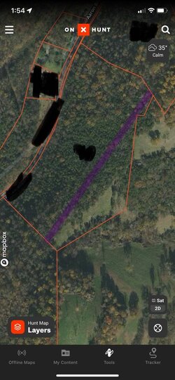
The purple line is where the line is supposed to be. That ridge field is mine so anybody using OnX would assume they could hunt that field, wrong.
 

Attachments

  • IMG_4273.jpeg
    IMG_4273.jpeg
    148 KB · Views: 20

Latest posts

Top