I am seriously looking into one and I want a really awesome one. Lets hear it and ease of use would be key also. I find these super useful in areas like lbl, and Eagle creek.........22,000 acres. I had one years ago and never really used it, lost it......................I want one that is advanced, large screen and easy to use. Please help.
You are using an out of date browser. It may not display this or other websites correctly.
You should upgrade or use an alternative browser.
You should upgrade or use an alternative browser.
Best Gps for hunting?
- Thread starter Boone 58
- Start date
The best gps for hunting in TN is your smartphone. Not even close. OnXHunt and you are good to go. I've had mine in the most remote areas of Cherokee NF in carter county you can get and zero issues.
Come home, log in the website and see every place I went. Overlay sat, topo, you name it. Mark it up on computer and walk right back to it with my phone.
See something you like, take a pic of it geo tags it and files it.
Tells you how far you went, how much elevation you gained, etc etc.
Pay the ~$25/year and it shows you private land and who owns it.
It can't be beat.
Sent from my iPhone using Tapatalk
LanceS4803
Well-Known Member
Boone 58":15siv3e1 said:In LBL there are issues with reception on my smart phone including all of Eagle Creek, and Laurel Hill wma....................not sure how you can work that.
With using your smartphone as a GPS, you aren't going off the cell towers. (In fact, put it on airplane mode to converse battery.)
It is going off saved maps and your phone's internal GPS.
I'm experimenting now with a few apps, haven't got OnXhunt yet, but from everything I've read, it is the best.
I have used multiple varieties of Garmins, from the eTrex, to the Oregon to the 64S which I have now. I really liked the Oregon and the 64s I have now is every bit as good.
Nsghunter
Well-Known Member
I always wanted a Garmin Montana 650t. but they are very pricey. I have never used on though.
Nsghunter
Well-Known Member
LanceS4803":3bur5wug said:Boone 58":3bur5wug said:In LBL there are issues with reception on my smart phone including all of Eagle Creek, and Laurel Hill wma....................not sure how you can work that.
With using your smartphone as a GPS, you aren't going off the cell towers. (In fact, put it on airplane mode to converse battery.)
It is going off saved maps and your phone's internal GPS.
I'm experimenting now with a few apps, haven't got OnXhunt yet, but from everything I've read, it is the best.
What types of cell phone are you using?
My ANdroid phone doesn't seem to do this. I know my Iphone did. Is there an option where I save the maps to my phone?
Nsghunter":13wii020 said:LanceS4803":13wii020 said:Boone 58":13wii020 said:In LBL there are issues with reception on my smart phone including all of Eagle Creek, and Laurel Hill wma....................not sure how you can work that.
With using your smartphone as a GPS, you aren't going off the cell towers. (In fact, put it on airplane mode to converse battery.)
It is going off saved maps and your phone's internal GPS.
I'm experimenting now with a few apps, haven't got OnXhunt yet, but from everything I've read, it is the best.
What types of cell phone are you using?
My ANdroid phone doesn't seem to do this. I know my Iphone did. Is there an option where I save the maps to my phone?
Yes. Great help section or support for onxhunt.
If I'm going to be somewhere with sketchy cell coverage (which I am a lot), I turn off my cellular data and whatnot to save battery life.
I have an iPhone but the app works the same on android.
Sent from my iPhone using Tapatalk
To add - don't get me wrong. Dedicated gps units are nice. But the gap has been closed, and since most people have a smart phone anyway, I can't imagine a reason to spend the money on a gps.
If I was going out west, I'd spend the money for some solar battery chargers or something.
Sent from my iPhone using Tapatalk
If I was going out west, I'd spend the money for some solar battery chargers or something.
Sent from my iPhone using Tapatalk
LanceS4803
Well-Known Member
Nsghunter":394svr94 said:LanceS4803":394svr94 said:Boone 58":394svr94 said:In LBL there are issues with reception on my smart phone including all of Eagle Creek, and Laurel Hill wma....................not sure how you can work that.
With using your smartphone as a GPS, you aren't going off the cell towers. (In fact, put it on airplane mode to converse battery.)
It is going off saved maps and your phone's internal GPS.
I'm experimenting now with a few apps, haven't got OnXhunt yet, but from everything I've read, it is the best.
What types of cell phone are you using?
My ANdroid phone doesn't seem to do this. I know my Iphone did. Is there an option where I save the maps to my phone?
Old iPhone 4S that a co-worker gave me. Doesn't even have cell subscription.
TheLBLman
Well-Known Member
Just a couple things to keep in mind when using a smart phone as your gps:
1) Waterproofness?
Unlike most dedicated gps units (such as Garmin, etc.), most smart phones are not even sweat proof ---- just a little moisture can mess them up. Yes, you "can" work around this with the proper after-market case ---- just note that most dedicated gps units are in fact waterproof right out of the box.
2) Battery life?
Using your smart phone as a gps can drain your battery quickly.
If you're using the same phone for both communications & as a gps, you can find yourself with neither when you may need both.
Personally, I typically carry a dedicated gps, a smart phone I also use as both a gps & for communications, and a separate "emergency" phone (carried in a small crushproof, waterproof case). Plus, extra power backup (which is simply extra AA batteries for the dedicated gps). I do like using the smart phone as a gps (love the bigger screen), but there are times the dedicated gps is more practical, such as navigating during a storm, such as needing that phone for talking, while navigating.
Carrying an extra old smart phone to be used as a gps sounds like a great idea.
Nice to have so many choices today")
Doesn't seem that long ago to me the only hand-held gps units had tiny monochrome screens with no mapping software, and they were relatively expensive considering today's capabilities.
1) Waterproofness?
Unlike most dedicated gps units (such as Garmin, etc.), most smart phones are not even sweat proof ---- just a little moisture can mess them up. Yes, you "can" work around this with the proper after-market case ---- just note that most dedicated gps units are in fact waterproof right out of the box.
2) Battery life?
Using your smart phone as a gps can drain your battery quickly.
If you're using the same phone for both communications & as a gps, you can find yourself with neither when you may need both.
Personally, I typically carry a dedicated gps, a smart phone I also use as both a gps & for communications, and a separate "emergency" phone (carried in a small crushproof, waterproof case). Plus, extra power backup (which is simply extra AA batteries for the dedicated gps). I do like using the smart phone as a gps (love the bigger screen), but there are times the dedicated gps is more practical, such as navigating during a storm, such as needing that phone for talking, while navigating.
Carrying an extra old smart phone to be used as a gps sounds like a great idea.
Nice to have so many choices today
Doesn't seem that long ago to me the only hand-held gps units had tiny monochrome screens with no mapping software, and they were relatively expensive considering today's capabilities.
TheLBLman
Well-Known Member
As an aside, especially if you're using your smart phone as your only gps unit, consider carrying an additional "emergency" phone.
I mainly use a small Tracfone.
It will provide service in areas of LBL (and elsewhere) where Verizon has zero service.
It is relatively "cheap" insurance.
I mainly use a small Tracfone.
It will provide service in areas of LBL (and elsewhere) where Verizon has zero service.
It is relatively "cheap" insurance.
El Jagermeister
Well-Known Member
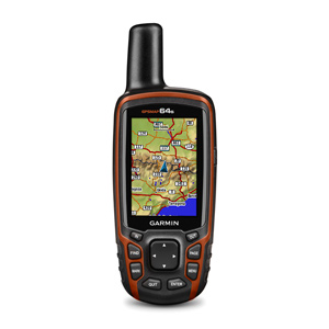
Most of the Western hunters apparently use a Garmin 64s. The antenna is very good and you can use it wearing gloves very easily due to the tactile buttons instead of a touchscreen. It's not as expensive as the upper scale Montana's, etc., but does everything you need it to and runs a long time on lightweight lithium AA batteries. It's a lot more rugged than a smartphone and doesn't keep you from using a phone if you run down the batteries.
I ordered one a few days ago and plan on using it for public land hunts. I've used my smartphone before and lost the tracking signal several times under the tree canopy where I hunt. This unit is supposedly very good under canopy. It uses GPS and GLONASS (the Russian's Satelite system) to help you maintain a usable signal.
You can put a microSD card in the unit and hold a ton of different maps, too. Or buy a specific hunting app chip for it like OnX. Then you can see property lines (and who the landowner is) on your screen.
I guess I made the right choice with mine. When it arrives, I'll test it out and let you guys know.
I
LanceS4803
Well-Known Member
El Jagermeister":mwaagiup said:Most of the Western hunters apparently use a Garmin 64s. The antenna is very good and you can use it wearing gloves very easily due to the tactile buttons instead of a touchscreen. It's not as expensive as the upper scale Montana's, etc., but does everything you need it to and runs a long time on lightweight lithium AA batteries. It's a lot more rugged than a smartphone and doesn't keep you from using a phone if you run down the batteries.
Thanks for the info. I'm going to check this out, but in the meantime, please report your review.
https://smile.amazon.com/Garmin-Wor...TF8&qid=1501811319&sr=8-3&keywords=Garmin+64s
smalljawbasser":2p42bpnm said:Pay the ~$25/year and it shows you private land and who owns it.
You have to be careful using these sorts of apps for land boundaries. I know of at least two pieces of property that are incorrectly marked on Onyx and the Tennessee Property Viewer website. I'm not talking about being off by a few feet. They show chunks of property belonging to the wrong people. The boundaries in these sorts of app don't come from the land deed, which is the real source of truth.
LanceS4803
Well-Known Member
TNReb":3s2b3lwt said:You have to be careful using these sorts of apps for land boundaries. I know of at least two pieces of property that are incorrectly marked on Onyx and the Tennessee Property Viewer website. I'm not talking about being off by a few feet. They show chunks of property belonging to the wrong people. The boundaries in these sorts of app don't come from the land deed, which is the real source of truth.
I recently dealt with inaccuracies and the Property Viewer. It came down to two problems:
Lag time from when the individual county cartographer uploaded the new property lines and/or owner. I've been told that delay can come from the county or the state.
Accuracy of cartographers interpretation of the deed. I've seen them misread (or not read at all) the deed. The ones I've worked with didn't want the actual new survey map, instead relying solely on the deed (which took the language directly from the survey).