Anybody know ?

philburr

Well-Known Member
Joined
Aug 27, 2006
Messages
770
Location
gallatin
Found these the other day ,never seen any markers like this
saids Webb 1933 on them ,all I saw was three could be
Anybody ever seen any thig like them

IMG_0343.jpg

IMG_0347.jpg

IMG_0345.jpg

IMG_0342.jpg
 

Physiksgeek

Well-Known Member
Joined
Nov 21, 2005
Messages
366
Location
Clarksville, Tn
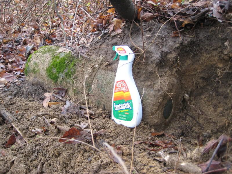
Any of this sound familiar???

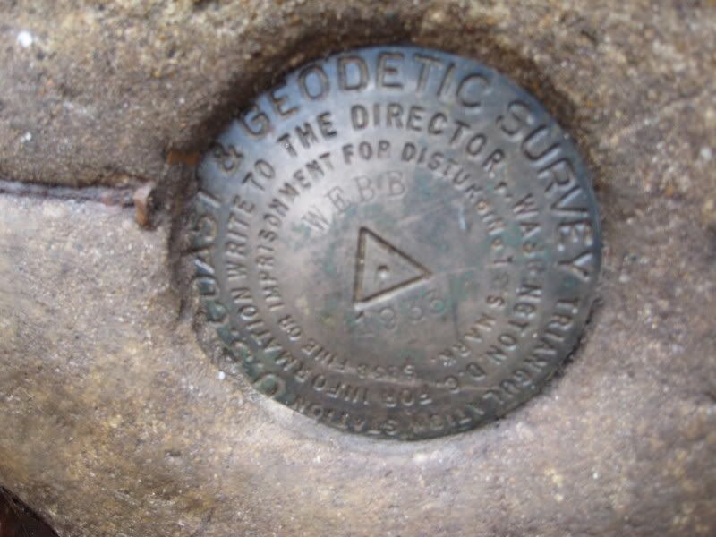
GC2100'DESCRIBED BY COAST AND GEODETIC SURVEY 1933 (GLA)
GC2100'ABOUT 10-1/2 MILES NORTH BY EAST OF GALLATIN, 7-1/2 MILES SOUTHEAST
GC2100'OF PORTLAND, ON WATERSHED BETWEEN BARREN AND CUMBERLAND
GC2100'RIVERS, ON WOOD LOT OWNED BY W. D. WEBB, ABOUT 350 METERS (1,148
GC2100'FEET) WEST BY NORTH OF MR. WEBBS HOUSE, 125 FEET WEST OF RAIL FENCE,
GC2100'40 FEET SOUTHEAST OF BLAZED 24-INCH DEAD CHESTNUT TREE, AND 35 FEET
GC2100'NORTH OF VERY LARGE STUMP. TO REACH FROM FRANKLIN, KY., FOLLOW U.S.
GC2100'ROUTE 31W SOUTH 7 MILES TO MITCHELLVILLE, TURN EAST ONTO STATE ROUTE
GC2100'109, GO 4.6 MILES TO JUNCTION WITH STATE ROUTE 52 IN PORTLAND,
GC2100'BEAR LEFT, PROCEED 1/2 MILE, CONTINUE STRAIGHT AHEAD 2-1/4 MILES ON
GC2100'STATE ROUTE 109 TO CROSSROADS, TURN LEFT, GO 1.7 MILES TO CROSSROAD,
GC2100'TURN RIGHT, GO 3.1 MILES TO DOBBINE PIKE, TURN RIGHT ONTO PIKE, GO
GC2100'1.2 MILES, TURN LEFT ONTO DIRT ROAD, GO 1.1 MILES TO JOG TO LEFT, AND
GC2100'CONTINUE STRAIGHT AHEAD 0.3 MILE ON WOODS ROAD TO TOP OF HILL AND
GC2100'STATION SITE. SURFACE AND UNDERGROUND MARKS ARE STANDARD DISK
GC2100'STATION MARKS IN CONCRETE. UPPER MARK PROJECTS 1
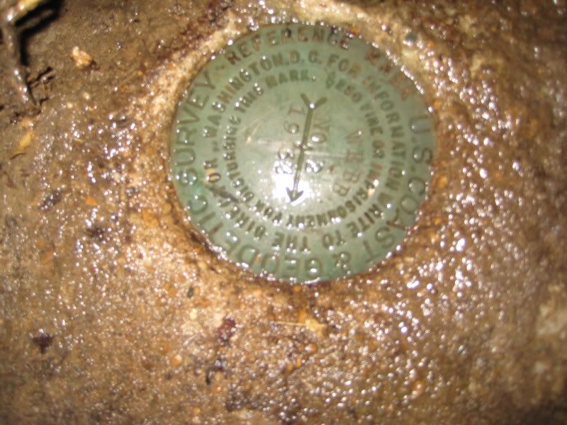
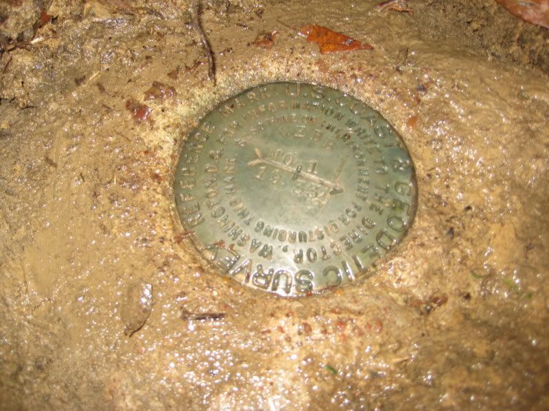
GC2100'INCH ABOVE GROUND. REFERENCE AND AZIMUTH MARKS ARE STANDARD
GC2100'REFERENCE DISKS SET IN CONCRETE CYLINDERS. NO. 1, PROJECTING 4 INCHES
GC2100'ABOVE GROUND, IS 45 FEET SOUTH OF VERY LARGE CHESTNUT TREE AND 72.63
GC2100'FEET FROM STATION, N 8 DEG 38 MIN E. NO. 2, PROJECTING 5
GC2100'INCHES ABOVE GROUND, IS 45 FEET WEST OF RAIL FENCE AND 82.44 FEET
GC2100'FROM STATION, S 71 DEG 58 MIN E. AZIMUTH MARK, PROJECTING 6
GC2100'INCHES ABOVE GROUND, IS IN FENCE LINE, ON SOUTH SIDE OF ROAD,
GC2100'NORTH OF MR. WEBBS HOUSE, AND APPROXIMATELY 0.3 MILE FROM STATION,
GC2100'S 53 DEG 03 MIN 07 SEC E.
GC2100
GC2100 STATION RECOVERY (1950)
GC2100
GC2100'RECOVERY NOTE BY COAST AND GEODETIC SURVEY 1950 (JAW)
GC2100'STATION, REFERENCE MARKS 1 AND 2, AND AZIMUTH MARK WERE RECOVERED AND
GC2100'FOUND TO BE IN GOOD CONDITION.


NOAA
Type in Webb, choose Tennessee and then search.
 

Physiksgeek

Well-Known Member
Joined
Nov 21, 2005
Messages
366
Location
Clarksville, Tn
philburr said:
Anybody ever seen any thig like them

Yes, There is one in Palmyra, Tn. indicating a high water mark. It is on a friends property on the Cumberland River. Don't quote me but I think it is marked 359 ft - 1928
 

philburr

Well-Known Member
Joined
Aug 27, 2006
Messages
770
Location
gallatin
lots more info than I was especting ,found then on the place next to mine. so what were they? and I wonder why dig them up?
 

Physiksgeek

Well-Known Member
Joined
Nov 21, 2005
Messages
366
Location
Clarksville, Tn
philburr said:
I found three of them all looked to be in dozer piles

philburr - I'm curious.....The same dozer pile or different? Reading my post earlier it says they were placed in round concrete cylinders less than a 80 feet from the station that was recovered in 1950. You may have found the the two references(No 1 and No 2) and the azimuth. Just curious?!?
 

philburr

Well-Known Member
Joined
Aug 27, 2006
Messages
770
Location
gallatin
Physiksgeek said:
philburr said:
I found three of them all looked to be in dozer piles

philburr - I'm curious.....The same dozer pile or different? Reading my post earlier it says they were placed in round concrete cylinders less than a 80 feet from the station that was recovered in 1950. You may have found the the two references(No 1 and No 2) and the azimuth. Just curious?!?

Found in three different piles , two were about 20 yards from each other,the last one was 75 yards away from the others
 

FULLDRAWXX75

Well-Known Member
Joined
Jan 29, 2007
Messages
6,227
Location
Adirondack Mtns, NY
As stated earlier, they are USGS benchmarks, I believe it is illegal to remove them. Not 110% sure on that, but I remember being told by a NYS Forest Ranger while hiking, taking them home is a no no.

FDXX75
 

Chaneylake

Well-Known Member
Joined
Dec 18, 2007
Messages
41,555
Location
on the wings of a snow white dove
tndrbstr said:
It is a benchmark. When I was working for an engineering company we would use them to set/calibrate an altimeter to the specific barametric pressure at the know altitude....The 1933 on these is the known feet above sea level, not the date....

please check on your info, I have been dealing with these type markers since 1973, the "1933" is probably the date, everyone that I have ever used was listed in a table that showed the elevation to the hundreth of a foot such as 487.52 feet
 

Latest posts

Top