Marking Property Line with AirTags

Tennessee Deer Sporting & Deer Hunting Community Forum

Help Support TNDeer | Tennessee Deer:

PaintRocker

Well-Known Member
Joined
Oct 27, 2022
Messages
59
City & State/Province
Loudon
The property I hunt I have noticed before that OnX does not put me close to my property line. I do not have good cell reception in that area so I was using an offline map. Got me to thinking on this rainy day, since the property line in question is straight can I put an AirTags at each corner and draw a line between them, how close would they get me to the property line. This property is all wooded a the line goes over a ridge. The neighboring property sold last year and is for sale again so I would probably put up posted signs if I can get close enough. Anybody have any experience with this or another idea?
 
The problem will be with the GPS accuracy of the airtags. I have no idea what their accuracy is, but it probably won't be better than 7 to 8 meters. Of course, that's relatively close for estimating the line, but certainly not "survey grade."
 
As an Amazon Associate we earn from qualifying purchases. Product prices and availability are accurate as of the date/time indicated and are subject to change.
The property I hunt I have noticed before that OnX does not put me close to my property line. I do not have good cell reception in that area so I was using an offline map. Got me to thinking on this rainy day, since the property line in question is straight can I put an AirTags at each corner and draw a line between them, how close would they get me to the property line. This property is all wooded a the line goes over a ridge. The neighboring property sold last year and is for sale again so I would probably put up posted signs if I can get close enough. Anybody have any experience with this or another idea?
If the owners are selling then there could be a new survey obtained when sold . Check your property lines then for a sure an accurate property line . Selling last year surely there could be at least corner markers .
 
If you can find the spot to add an airtag, then why not just use a GPS to get accurate location data? I used to do Geocaching, and the coordinates are good enough to find film canister (and smaller) sized geocaches, so it is very accurate, not survey accurate, but good enough. Then, you can plot out the corners on a map and lay out your lines.
 
If you can find the spot to add an airtag, then why not just use a GPS to get accurate location data? I used to do Geocaching, and the coordinates are good enough to find film canister (and smaller) sized geocaches, so it is very accurate, not survey accurate, but good enough. Then, you can plot out the corners on a map and lay out your lines.
Sounds like the same thing just a different approach
 
Sounds like the same thing just a different approach
Yes, more or less, except that you don't have to get any airtags if you already have a decent GPS. I also believe that a dedicated GPS is more accurate than most phones, and do not rely on cell service. Not familiar with the accuracy of airtags, so they may work great, and if you already have them then sure, go for it.
 
Most hand-held GPS units have accuracy in the 7 meter range. Which means, marking a corner point on your GPS is going to get you within 20 feet. That's pretty accurate if you're then going to draw a line from corner to corner on a digital map, like OnX.

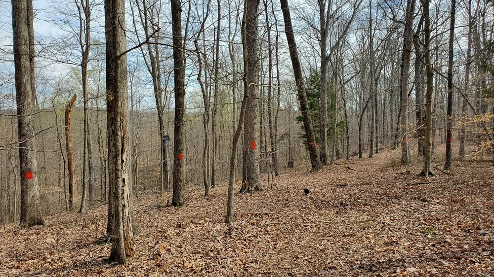
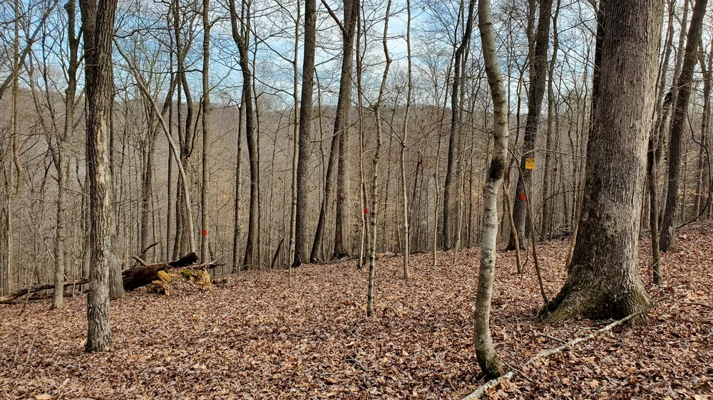
I was able to use a line marked on OnX to get close enough to mark/paint an unmarked property line. Just to be sure, as I was walking down the line on the GPS, I would mark trees a few paces off the line to make sure - in case of GPS error - I wasn't accidentally marking on the wrong side of the line. But as long as I stayed 8-12 feet off the GPS line, I should be good.

Orange paint markings and No Trespassing signs:
 

Attachments

  • Paint1.webp
    Paint1.webp
    278.7 KB
  • Paint2.webp
    Paint2.webp
    278.8 KB
I'm not hijacking the thread.but with today's technology. Why is it not possible to survey your own property. If already have the coordinates. I ask this out of ignorance of the subject on my part.
I'll add to this question...
How do you know reference points? I pulled my deed and none of the landmarks used in it are there anymore. There are pins in the ground, but my wife says they were loose and looked like they had been moved. She says the boundary lines between my neighbors property and our property shown on the country website; she doesn't think are correct.
 
I'm not hijacking the thread.but with today's technology. Why is it not possible to survey your own property. If already have the coordinates. I ask this out of ignorance of the subject on my part.
A professional surveyor has gps equipment that cost 50 to 100 thousand dollars. Way more precise than my garmin gps which is more precise than my iPhone.
 
Go to the courthouse get a map and post it
But the problem is everything lines up on the online web and courthouse map…for our property - tnpropertyassessment website, OnX, Huntstand, etc… but when you walk it, the blue pins in the ground clearly indicate the property lines.

Oh what I would give to have what the online and courthouse lines say we should have. It shows we should have another approximately 200 yard wide by approximately 500 yard long strip of timber. Now this property in whole is huge (not a small piece of land where this questionable portion makes a whole lot of difference)….BUT there's still (to most, and me too) a whole lot of difference

Maybe the pins in the ground set 40+ years ago were wrong and I need to call and get them to reassess that portion? I don't know?? 🤷‍♂️
 
I'm not hijacking the thread.but with today's technology. Why is it not possible to survey your own property. If already have the coordinates. I ask this out of ignorance of the subject on my part.
The question is, survey your own property with what equipment? Surveying is actually quite complicated. Understanding the geometry, as well as ground measurement systems and map projections, is something people go to school for years to master.
 
But the problem is everything lines up on the online web and courthouse map…for our property - tnpropertyassessment website, OnX, Huntstand, etc… but when you walk it, the blue pins in the ground clearly indicate the property lines.

Oh what I would give to have what the online and courthouse lines say we should have. It shows we should have another approximately 200 yard wide by approximately 500 yard long strip of timber. Now this property in whole is huge (not a small piece of land where this questionable portion makes a whole lot of difference)….BUT there's still (to most, and me too) a whole lot of difference

Maybe the pins in the ground set 40+ years ago were wrong and I need to call and get them to reassess that portion? I don't know?? 🤷‍♂️
Everything would come down to whether the pins match the legal deed descriptions. In that, if you go through the survey calls (such as: from Point A, travel 127 degrees, 27 minutes, 5 seconds, for a distance of 169.6 feet to Point B), are the pins at the designated position? If not, how far off are they (a foot or two, or 100 yards?).
 
We used a laser level at night between two corner markers and apparently it was accurate and honest because surveyors marked the fence we built as the line two years later.
 
But Bluetooth only reaches a very limited distance, so I don't understand how this would help him see property lines - unless he had dozens of them placed like every 100 feet along the line. I guess maybe I'm missing something here.
It would allow him to draw a line from corner to corner on a mapping app, IF he knows the exact location of the corner points. Then, using the mapping app, he could walk along (or very near) his property line.
 
The question is, survey your own property with what equipment? Surveying is actually quite complicated. Understanding the geometry, as well as ground measurement systems and map projections, is something people go to school for years to master.
My deed says walk so many feet to this branch to so many feet to this tree to so many feet to 3 elm trees. I'm looking it over now. And no I couldn't do a 100 percent not even half of that probably in accuracy. I would just like to find some markers. But this survey was done in the early 80's. So not sure what they used back then. But they're probably gone by now. What would happen if you had it surveyed and it turns out you have more land then you thought or just say tax paper says. ?
 
My deed says walk so many feet to this branch to so many feet to this tree to so many feet to 3 elm trees. I'm looking it over now. And no I couldn't do a 100 percent not even half of that probably in accuracy. I would just like to find some markers. But this survey was done in the early 80's. So not sure what they used back then. But they're probably gone by now. What would happen if you had it surveyed and it turns out you have more land then you thought or just say tax paper says. ?
Those historical boundaries are just that, 25 steps past the leaning white oak tree, and you turn yourself around…

The first time I read one I thought it was a joke.
 

Latest posts

Back
Top